







China is conducting a vast undersea mapping and monitoring operation across the Pacific, Indian and Arctic oceans, building detailed knowledge of marine conditions that naval experts say would be crucial for waging submarine warfare against the United States and its allies.
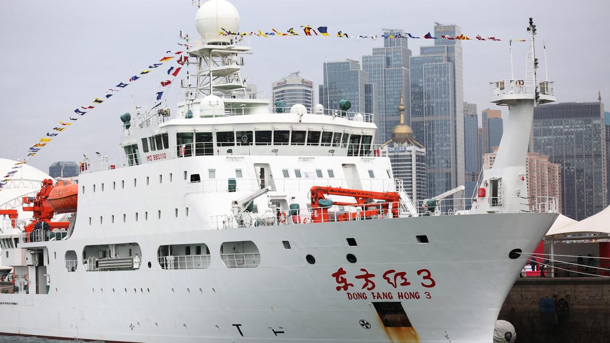
In one example, the Dong Fang Hong 3, a research vessel operated by Ocean University of China, spent 2024 and 2025 sailing back and forth in the seas near Taiwan and the U.S. stronghold of Guam, and around strategic stretches of the Indian Ocean, ship-tracking data reviewed by Reuters shows. In October 2024, it checked on a set of powerful Chinese ocean sensors capable of identifying undersea objects near Japan, according to Ocean University, and visited the same area again last May. And in March 2025, it criss-crossed the waters between Sri Lanka and Indonesia, covering approaches to the Malacca Strait, a critical chokepoint for maritime commerce.

According to the university, the ship was carrying out mud surveys and climate research. But a scientific paper co-written by Ocean University academics shows it has also conducted extensive deep-sea mapping. Naval-warfare experts and U.S. Navy officials say the type of deep-sea data being collected by the Dong Fang Hong 3 – via mapping and placement of sensors in the ocean – is giving China a picture of the subsea conditions it would need to deploy its submarines more effectively and hunt down those of its adversaries.
The Dong Fang Hong 3 isn’t operating alone. It is part of a broader ocean mapping and monitoring operation involving dozens of research vessels and hundreds of sensors. In tracing this effort, Reuters examined Chinese government and university records, including journal articles and scientific studies, and analysed more than five years of movement by 42 research vessels active in the Pacific, Indian or Arctic oceans using a ship-tracking platform built by New Zealand company Starboard Maritime Intelligence.
While the research has civilian purposes – some of the surveying covers fishing grounds or areas where China has mineral prospecting contracts – it also serves a military one, according to nine naval-warfare experts who reviewed Reuters’ findings.

To gather information about underwater terrain, research vessels map the sea floor while traveling back and forth in tight lines. The tracking data shows that type of movement by the vessels Reuters tracked across large sections of the Pacific, Indian and Arctic oceans.
At least eight of the vessels Reuters tracked have conducted seabed mapping, while another 10 have carried equipment used for mapping, according to a review of Chinese state media articles, vessel descriptions published by Chinese universities, and press releases by government organisations.
The vessels’ survey data “would be potentially invaluable in preparation of the battlespace” for Chinese submarines, said Peter Scott, a former chief of Australia’s submarine force. “Any military submariner worth his salt will put a great deal of effort into understanding the environment he’s operating in.”
The ship-tracking data show that China’s seabed-surveying effort is focused in part on militarily important waters around the Philippines, near Guam and Hawaii, and near U.S. military facilities on Wake atoll in the north Pacific. “The scale of what they’re doing is about more than just resources,” said Jennifer Parker, an adjunct professor of defense and security at the University of Western Australia and former Australian anti-submarine warfare officer. “If you look at the sheer extent of it, it’s very clear that they intend to have an expeditionary blue-water naval capability that also is built around submarine operations.”
Moreover, Parker and other experts added, even where data is gathered for scientific purposes, the integration of civilian scientific research and military technology development has become a key focus of the Chinese government under President Xi Jinping. Beijing refers to this approach as “civil-military fusion.”
China’s ministries of defense, foreign affairs and natural resources didn’t respond to requests for comment about the seabed mapping and ocean-monitoring activities. The U.S. Defense Department didn’t respond to questions from Reuters.
In testimony to a congressional commission this month, Rear Admiral Mike Brookes, the commander of the U.S. Office of Naval Intelligence, said China had dramatically expanded its surveying efforts, providing data that “enables submarine navigation, concealment, and positioning of seabed sensors or weapons.” He added that “potential military intelligence collection” by Chinese research vessels “represents a strategic concern.”
America recently overhauled its own efforts to map and monitor the ocean, but it typically does so with military vessels that are allowed to turn off the tracking system monitored by civilian software. China’s civilian survey ships also sometimes disable tracking, meaning its campaign may go further than Reuters could determine.
This is the first time the extent of China’s mapping and monitoring across the Pacific, Indian and Arctic oceans has been reported. Previous reporting has revealed a portion of the effort around Guam and Taiwan, and in parts of the Indian Ocean. “It is frankly astonishing to see the enormous scale of Chinese marine scientific research,” said Ryan Martinson, an associate professor specializing in Chinese maritime strategy at the U.S. Naval War College.
“For decades, the U.S. Navy could assume an asymmetric advantage in its knowledge of the ocean battlespace,” added Mr. Martinson. China’s efforts “threaten to erode that advantage. It is obviously deeply concerning.”
Paranoid about being boxed in
The data that Chinese research vessels are collecting about the seabed and water conditions is critical to submarine operations and anti-submarine warfare, according to naval experts. Most obviously, said Australian defense scholar Parker, commanders need information about underwater terrain to avoid collisions and hide their vessels. But that data is also essential for detecting submarines, which operate within a few hundred meters of the surface.
Typically, submarines are identified through the sounds they emit or echoes from signals sent by sonar systems. Tom Shugart, a former U.S. submarine commander who is now an adjunct senior fellow at the Center for a New American Security, said the movement of those sound waves changes depending on the underwater landscape.
Sound waves and submarine movements are also affected by water temperature, salinity and currents. The vessels involved belong to Chinese state entities like the Ministry of Natural Resources or state-affiliated research institutions like Ocean University, whose president in 2021 publicly celebrated its “close ties” to China’s navy and commitment to “the construction of a maritime power and national defense.” The university didn’t respond to a request for comment.
China has done its most comprehensive ocean surveying east of the Philippines, which sits along the First Island Chain, the string of territories largely controlled by America’s allies that runs from the Japanese islands in the north through Taiwan and on to Borneo in the south. The chain forms a natural barrier between China’s coastal seas and the Pacific. “They’re paranoid about being boxed in to the First Island Chain,” said Peter Leavy, formerly Australia’s naval attache to the U.S. and now president of the Australian Naval Institute.
China’s mapping “indicates a desire to understand the maritime domain so they can break out.” The tracking data shows that China’s mapping also covers waters surrounding Guam – where some American nuclear submarines are stationed.
Strikingly, Chinese vessels have also mapped waters around Hawaii, one of America’s other regional military hubs; examined an underwater ridge north of a naval base in Papua New Guinea to which the U.S. recently gained access; and scouted around Christmas Island, an Australian territory on a route between the South China Sea and a vital Australian submarine base.
China’s efforts extend further. It has mapped large swaths of the Indian Ocean, a critical route for Chinese imports of oil and other resources from the West Asia and Africa. “China has some key vulnerabilities when it comes to dependencies on maritime trade,” said Mr. Parker, the former anti-submarine warfare officer. The surveying “indicates that they will likely be conducting more submarine operations in the Indian Ocean.”
China’s vessels have also mapped the seabed west and north of Alaska, an essential sea route into the Arctic. Beijing has identified the Arctic as a strategic frontier and declared its ambition to become a polar great power by the 2030s. The extensive surveying and Beijing’s growing undersea capability are “symptomatic of China’s rise as a premier maritime power,” said Mr. Shugart, the former submarine commander.
A transparent ocean
Around 2014, Wu Lixin, a scientist at Ocean University, proposed an ambitious effort to create a “transparent ocean” by deploying sensors that would give China a comprehensive view of water conditions and movement through specific areas, according to a statement published by the state-affiliated Chinese Academy of Sciences. The proposal quickly received at least $85 million in support from the Shandong provincial government, according to comments by Shandong officials.
The project began in the South China Sea, where Ocean University public statements boast it has now built an observation system covering the deep-sea basin. Mr. Brookes, the director of the U.S. Office of Naval Intelligence, told the congressional commission that China is building undersea surveillance networks that “gather hydrographic data – water temperature, salinity, currents – to optimise sonar performance and enable persistent surveillance of submarines transiting critical waterways like the South China Sea.”
After surveying the South China Sea, Chinese scientists expanded the transparent ocean project to the Pacific and Indian oceans. In the Pacific, records from the Chinese Ministry of Natural Resources, Ocean University and the Shandong government show that China has deployed hundreds of sensors, buoys and subsea arrays to detect changes in water conditions like temperature, salinity and subsea movement through the ocean east of Japan, east of the Philippines, and around Guam.
In the Indian Ocean, documents from the Chinese Academy of Sciences and Ministry of Natural Resources describe a sensor array ringing India and Sri Lanka, including along an underwater mountain range known as Ninety East Ridge. The ridge – which Chinese vessels have also combed, according to the Starboard data – is one of the world’s longest undersea mountain ranges and sits astride the approach to the strategically essential Malacca Strait, through which much of China’s oil supply passes.
Ocean University and the Institute of Oceanology, which is part of the Chinese Academy of Sciences, have said the wider network of sensors now provides China with real-time data about water conditions and subsea movements. Some naval-warfare experts expressed caution about that claim, given technical challenges with real-time communication of data from underwater. But even delayed data is valuable, Mr. Parker said, as it could help China detect U.S. submarine operations.
Many sensors are placed in sensitive locations. For example, Reuters recently reported on a U.S. effort to fortify a key strait between Taiwan and the Philippines to cut off Chinese access to the Pacific. Ocean University studies show that China has deployed advanced sensors in parts of the strait through which U.S. submarines would move to reach the South China Sea. Chinese scientists say these sensors monitor changes in climate and ocean conditions. But in 2017, government officials from Shandong province said the transparent ocean project was intended to “ensure maritime defense and security” and explicitly compared the project with a U.S. military effort to build an American ocean-sensor network.
Shandong’s government, the Chinese Academy of Sciences and the Institute of Oceanology didn’t respond to requests for comment.
Mapping-program founder Wu now oversees the network through the Qingdao National Laboratory for Marine Science and Technology, whose partners include China’s Naval Submarine Academy, according to the academy’s website. Wu didn’t respond to Reuters questions.
New types of combat capabilities
Together, China’s mapping and monitoring give it sophisticated tools to detect rival submarines and deploy its own in some of the world’s most contested waters. “This is a manifestation of China’s far-seas reach,” said Collin Koh, a senior fellow in maritime security at Singapore’s RSIS Institute of Defence and Strategic Studies. “They now have a reasonably good picture of the maritime domain they hope to operate in, either in peacetime or in war.” Chinese researchers, similarly, see strategic value in their work. Zhou Chun, an Ocean University researcher who oversees the Indian and Pacific ocean sensor arrays, was quoted last year in an Ocean University press release as saying that his work had shown him “the rapid development of my country’s maritime defense and military capabilities.” He didn’t respond to Reuters questions.
Going forward, Mr. Zhou pledged to “transform the most advance dscientific and technological achievements into new types of combat capabilities for our military at sea.”