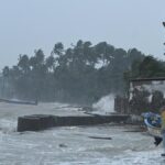


Rough sea and heavy rains in Pamban.
| Photo Credit: L. Balachandar
Torrential downpour triggered by Cyclone Ditwah battered several south coastal and delta districts of Tamil Nadu since Friday (November 28, 2025) night, inundating residential pockets, damaging standing crops and submerging salt pans even as the system continued to inch towards the north Tamil Nadu coast.
The Regional Meteorological Centre (RMC) has forecast that intense downpour would be largely confined to northern Tamil Nadu on Sunday (November 30, 2025) before rainfall and surface winds begin to gradually ease from Monday (December 1, 2025). North Tamil Nadu, including Chennai, began receiving intermittent spells of rain from Saturday (November 29, 2025) afternoon.
The cyclone picked up pace and moved with a speed of 10 kmph over southwest Bay of Bengal and adjoining north Sri Lanka, about 350 km south of Chennai, on Saturday evening. The storm will be centered over southwest Bay of Bengal within 50 km from the Tamil Nadu-Puducherry coast by early Sunday (November 30, 2025) morning and move closer to around 25 km by the evening.
B. Amudha, head, (additional in-charge), RMC, said the cyclone is likely to move parallel to the Tamil Nadu coast till Sunday and lose intensity as a depression from Sunday evening when it reaches close to Chennai. However, landfall is not expected.
Delta districts affected
Heavy rain pounded the delta districts, submerging vast stretches of paddy fields, particularly in Nagapattinam, Tiruvarur, and Mayiladuthurai, posing a threat to young crops. During the past 24 hours till 8.30 a.m. on Saturday, Kodiayakarai in Nagapattinam district received extremely heavy rainfall of 25 cm followed by Vedaranyam (19 cm).

The Mechanised fishing boats anchored at Kasimedu Fishing harbour in Chennai on November 29, 2025
| Photo Credit:
B. Velankanni Raj
According to official estimates, standing paddy crops raised on about 22,000 hectares in Nagapattinam district remain underwater. Large tracts of salt pans along Vedaranyam and Kodiyakarai coast have also been inundated.
Tiruvarur Collector V. Mohanachandran said flooding has been reported in paddy fields across four low-lying blocks, including Thiruthuraipoondi and Nannilam. The affected paddy crops were between 20 and 25 days’ old and the district administration was closely monitoring the situation.
Rameswaram worst hit
Rameswaram in Ramanathapuram district was among the worst affected, with residents in localities such as Gandhi Nagar and Natarajapuram stranded due to flooding. Some express trains originating from Rameswaram were partially or fully cancelled. Fishing vessels remained anchored as fishermen in Thoothukudi, Rameswaram and Kanniyakumari stayed off the sea this week, noted officials of the Fisheries Department.
Ramanathapuram District Collector Simranjeet Singh Kahlon interacted with people in relief centres about the facilities available.

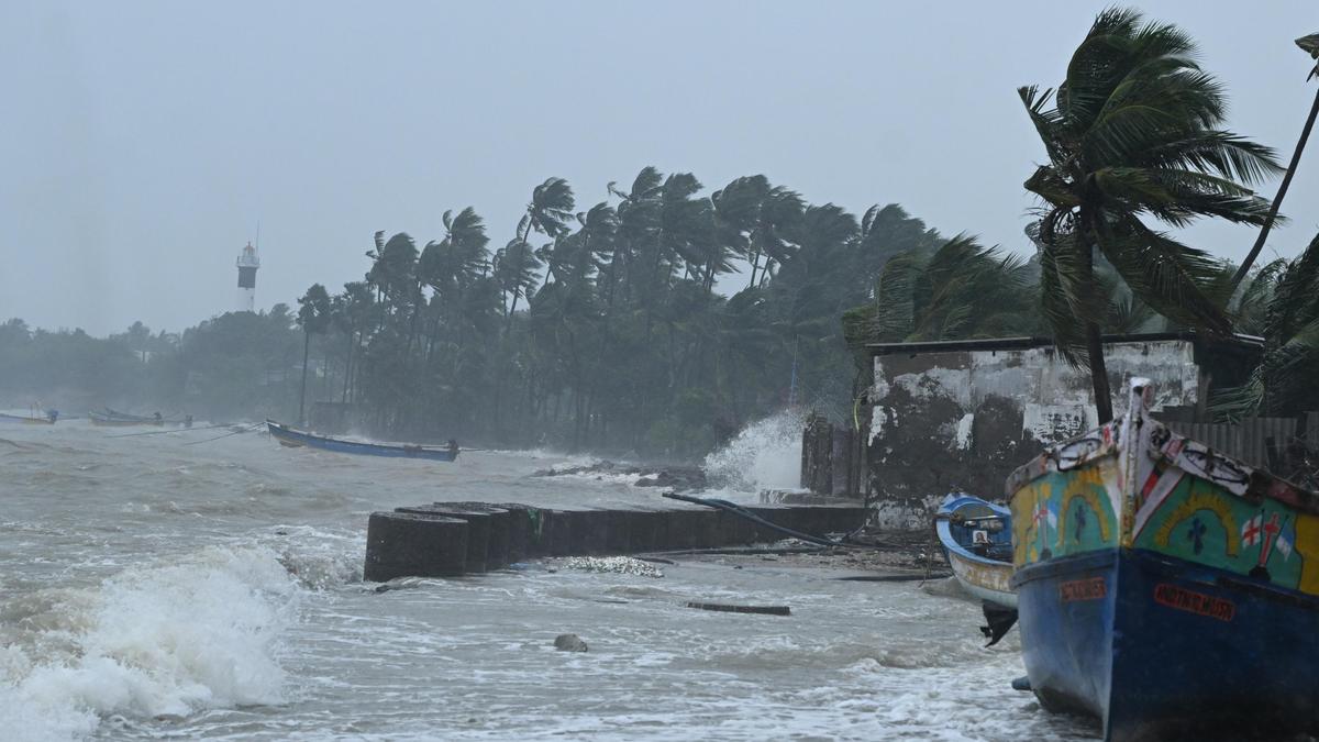
Heavy rains continue to lash Pamban and surrounding areas on November 29, 2025.
| Photo Credit:
L. Balachandar
In Chennai, discharge from key drinking water reservoirs was steadily increased following an orange alert issued for the city and neighbouring districts. Flood warnings were issued to downstream areas, including Chembarambakkam reservoir. The RMC has issued a red alert indicating extremely heavy rainfall in Tiruvallur and Ranipet districts on Sunday.
Published – November 29, 2025 08:46 pm IST