


A new satellite-based assessment by the Centre for Research on Energy and Clean Air (CREA), an international independent research organisation, reports widespread PM2.5 pollution across India’s districts, States and airsheds, and recommends expanding clean air planning beyond city boundaries.
The report, titled ‘Beyond city limits: A satellite-based PM2.5 assessment across India’s airsheds, States, and districts’, by Manoj Kumar, Monish Raj, Panda Rushwood, and Rosa Gierens, applies population‑weighted PM2.5 estimates using satellite data and ground measurements to evaluate annual and seasonal exposure.
PM2.5 refers to fine particulate matter measuring 2.5 micrometres or less in diameter, a key indicator of air pollution.

CREA’s district-level analysis finds that 60% of India’s districts (447 out of 749) exceed the annual National Ambient Air Quality Standard (NAAQS) for PM2.5 of 40 micrograms per cubic metre (µg/m³), and none meet the World Health Organisation (WHO) guideline of 5 µg/m³. This unit, µg/m³, refers to micrograms of particulate matter per cubic metre of air, a standard measure of air pollution concentration.
The data show large disparities in exposure — annual means range from 21 µg/m³ in Tiruppur, Tamil Nadu to 112 µg/m³ in the Northwest districts of Delhi. Several States and Union Territories record universal non‑compliance, including Delhi, Assam, Punjab, Haryana, Chandigarh, Himachal Pradesh, Meghalaya, Tripura, and Jammu & Kashmir.
The top 50 most polluted districts are concentrated in Delhi (11) and Assam (11), followed by Haryana (seven) and Bihar (seven). Other contributors include Uttar Pradesh (four), Tripura (three), Rajasthan (two), West Bengal (two), and one district each from Chandigarh, Meghalaya, and Nagaland.
At the State level, 28 of the 33 States and Union Territories assessed have at least one district exceeding the NAAQS, and none meet the WHO guideline.

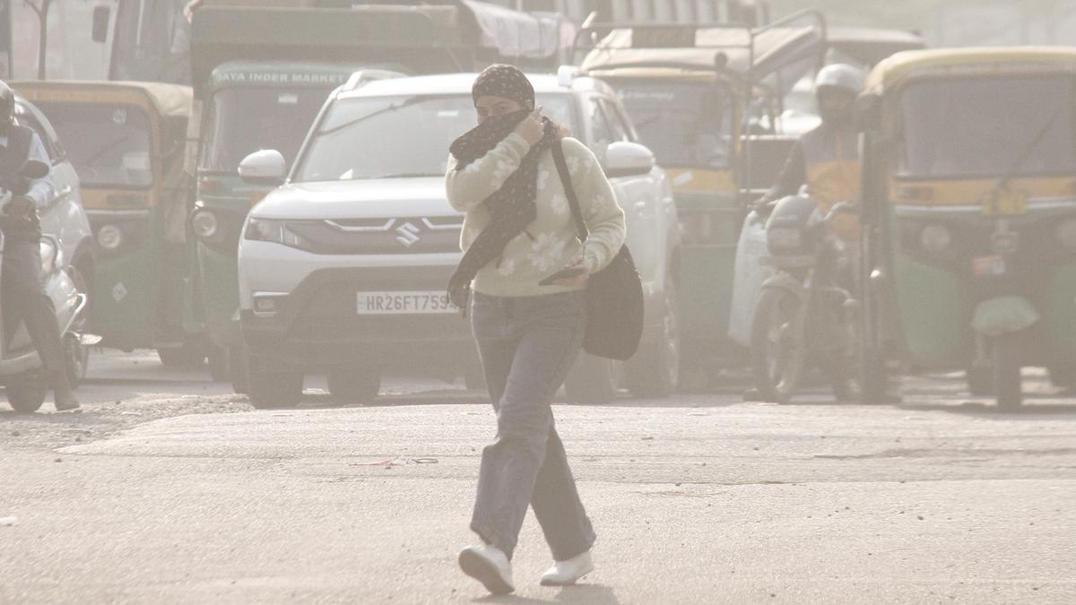
Delhi ranks as the most polluted, recording a population‑weighted annual PM2.5 of 101 µg/m³, which is 2.5 times the NAAQS and 20 times the WHO guideline.
States and Union Territories located in the Indo‑Gangetic Plain, including Chandigarh, Haryana, Punjab, Uttar Pradesh, Himachal Pradesh, Uttarakhand, and Jammu & Kashmir, show State-wide averages above the NAAQS. Eastern and northeastern States — Bihar, West Bengal, Jharkhand, Odisha, Assam, Meghalaya, Nagaland, Tripura, Arunachal Pradesh — also exceed the national standard.
Apart from Sikkim in the Northeast, southern India records the lowest averages, with Puducherry at 25 µg/m³, followed by Tamil Nadu, Karnataka, Telangana, Kerala, and Andhra Pradesh, all below the NAAQS but still above the WHO guideline.
Seasonal analysis indicates significant variation across the year. In winter (December to February), 616 of 749 districts (82%) exceed the NAAQS, associated with increased emissions and stagnant weather. During summer (March to May), the number of exceedances declines to 405 districts (54%). The monsoon (June to September) brings the greatest improvement, with 74 districts (10%) exceeding the standard, primarily due to rainfall‑induced atmospheric cleansing. Post‑monsoon (October to November) sees a resurgence, with 566 districts (75%) exceeding the limit.
At the State‑level, 22 of 33 States record 100% of districts above the NAAQS in winter, and nine States report 100% exceedance during summer.
Assam (21 districts), Delhi (nine), Punjab (15), and Tripura (six) exceed standards even during the monsoon, when much of India experiences cleaner air.

The study analyses airsheds, defined as regions where air moves and mixes in common patterns influenced by geography and weather. Airshed boundaries shift seasonally with wind and temperature changes. The Indo‑Gangetic airshed remains consistently non‑compliant across winter, summer, and post‑monsoon.
The Northeast airshed emerges as a year‑round concern, with Assam and Tripura maintaining elevated PM2.5 even during the monsoon. According to the report, most airsheds were below NAAQS during the monsoon, except for the Assam-Tripura airshed. The rapid return to high PM2.5 levels after the monsoon is presented as evidence that baseline emissions, not meteorology, are the fundamental problem.
“Without airshed‑based governance frameworks, satellite monitoring integration into NCAP (National Clean Air Programme), sectoral emission targets, and accountability mechanisms, millions in non‑metropolitan India will remain locked out of clean air policy and locked into chronic pollution exposure,” the report says.
CREA also says it is building near real-time tools for public use. “To make air quality information more accessible and actionable, CREA is developing daily PM2.5 concentration maps for India. These maps will soon be available for public use, helping policymakers, researchers, and citizens track pollution patterns and support data‑driven air quality management,” Mr. Kumar added.
The report highlights potential monitoring biases where station locations may under‑represent industrial corridors or heavy‑traffic micro‑environments in States with sparse networks. Delhi’s dense ground monitoring is cited as aligning well with satellite‑derived PM2.5, indicating improved capture of local spatial variations compared to most States with fewer stations. The study suggests that expanding and better siting ground monitors can improve accuracy and representativeness nationwide, while satellite observations provide consistent coverage to fill spatial gaps.
The PM2.5 data was generated using a machine-learning model based on Kawano et al (2025). Daily estimates at 10 km resolution were produced for all of India using satellite observations of aerosols, NO₂ (nitrogen dioxide), and CO (carbon monoxide), combined with weather data. The model covered the period from September 2018 to March 2025.
CREA has presented policy recommendations focused on aligning air quality management with regional and sectoral realities. The recommendations include developing district‑level clean air action plans beyond the current non‑attainment city list; formal integration of satellite‑derived PM2.5 data into the NCAP for comprehensive assessment, validation and public dissemination; targeting regional and sectoral emission sources, including power generation, industrial activity, biomass burning, and transport, especially in the Indo‑Gangetic Plain and northeastern States; incentivising State‑level accountability by linking clean air performance to fiscal mechanisms using standardised indicators from both satellite and ground data; and adopting airshed‑based management frameworks to coordinate emission reduction, and joint monitoring and accountability across neighbouring jurisdictions.
The report notes opportunities for differentiated targets. The southern States with annual PM2.5 levels below the NAAQS can move toward WHO interim targets by adopting stricter, region‑specific limits, enabling progressive improvement while recognising differences in baseline emissions across States.
Within Maharashtra, CREA points to disparities between the State’s overall average, near the NAAQS threshold, and district‑level hotspots. Fourteen of 36 districts exceed the annual PM2.5 standard in Maharashtra. Reported annual means (µg/m³) include Ratnagiri (47.77), Raigarh (47.03), Gadchiroli (46.81), Dhule (42.83), Chandrapur (42.43), Jalgaon (42.38), Thane (41.63), Sindhudurg (41.60), Nashik (40.49), Ahilyanagar (formerly Ahmadnagar, 40.34), Aurangabad (40.41), Nandurbar (41.16), Palghar (41.13), and Pune (40.03). Seasonal data show Mumbai averaging 37.07 µg/m³ annually but 63.17 µg/m³ in winter; Raigarh at 47.03 µg/m³ annually, with 66.08 µg/m³ in winter and 60.17 µg/m³ in the monsoon; Ratnagiri at 47.77 µg/m³ annually, with 68.86 µg/m³ in winter and 58.85 µg/m³ in the monsoon. The report describes Chandrapur as hosting dense clusters of coal‑based industries and power plants, with consistent exceedance of the annual standard.
Due to limitations in ground monitoring during the study period, Ladakh, the Andaman and Nicobar Islands, and Lakshadweep were excluded from the assessment. The remaining 33 States and Union Territories, covering 749 districts, were included. Seasonal airsheds, varying between nine and 11 in number, were analysed to examine regional variations, Mr. Kumar said.