






The story so far:
Nine months after the Telangana Government redrew the policing map of Hyderabad and its suburbs, it has returned to the exercise with another round of changes. Government Orders issued on September 30 modify police jurisdictions across Hyderabad, Cyberabad, and Malkajgiri commissionerates, creating a new Law and Order zone and divisions, realigning traffic and other wings, and correcting boundaries at the police station level.
The changes built on the December 29, 2025 reorganisation replaced the familiar ‘tri-commissionerate’ arrangement of Hyderabad, Cyberabad and Rachakonda with four commissionerates. So, why has the map changed again, and what do the latest changes mean?

Why was another rejig necessary?
The three commissionerates had roots in an earlier restructuring in 2016, when the geographically vast Cyberabad Commissionerate was split, with Cyberabad East subsequently becoming Rachakonda.
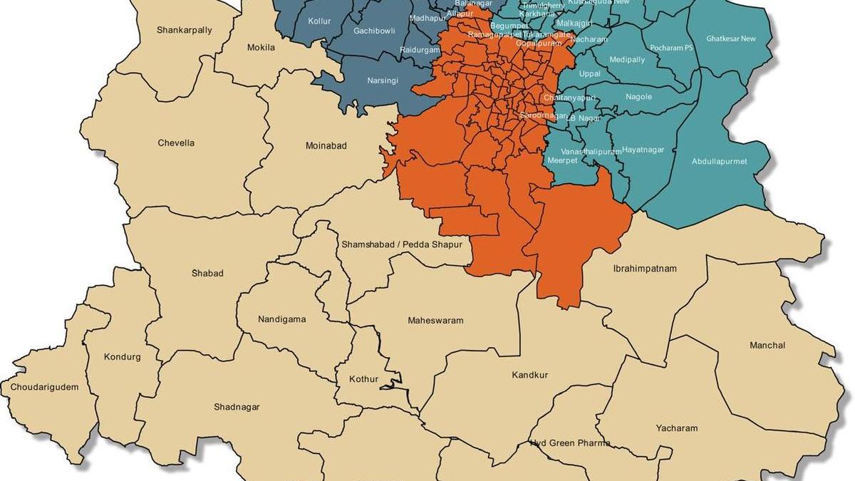
The December reorganisation placed major State institutions and sensitive locations, including the Assembly, Secretariat, Begumpet and Shamshabad airport, under Hyderabad. The western IT and industrial corridors, including Gachibowli, Financial District, Nanakramguda, Madhapur, Raidurg, Patancheru, Genome Valley, Ramachandrapuram and Ameenpur, remained with Cyberabad. Malkajgiri emerged from the erstwhile Rachakonda structure, while Chevella, Moinabad, Shankarpally, Maheshwaram and Ibrahimpatnam were among the areas brought under the newly created Future City Commissionerate.
By July 2026, implementation of certain aspects of the December orders remained incomplete, leading to confusion over territorial jurisdictions. A review was consequently undertaken to settle police station limits while considering municipal boundaries, revenue divisions and court jurisdictions, along with future urban expansion, population growth and administrative requirements.
The objective of the reshuffle is to bring the geographical limits of the police commissionerates and their constituent units more closely in line with the corresponding municipal areas, according to a senior official involved in the exercise. This is intended to reduce instances where civic and police jurisdictions cut across each other, making administration and coordination more cumbersome.
The exercise has also involved a wider rationalisation of police jurisdictions. Territorial contiguity, the crime profile of different areas and policing requirements on the ground were among the considerations while deciding where the boundaries should fall. The requirement for greater traffic policing and Women Police presence in certain areas was also assessed.
As part of this rationalisation, police station and divisional jurisdictions have now been more clearly defined. New units have been created where required, while some existing jurisdictions have been merged or reorganised. The September 30 orders consequently go beyond merely moving neighbourhoods from one commissionerate to another: they seek to make the Law and Order, Traffic and Women Safety structures correspond more closely with the revised territorial arrangement.

The expectation is that clearer and more contiguous jurisdictions will make the system easier to administer and, in the longer run, easier for residents to navigate. Residents uncertain about which police station now covers their neighbourhood can refer to the police website to identify the jurisdiction under which their area falls.
The September 30 orders are therefore better understood as a second-stage rationalisation of the four-commissionerate structure created in December, ironing out jurisdictional overlaps and operational issues that became apparent as the new policing map was put into practice.
What changes in the ‘quad commissionerates of Hyderabad’?
The most substantial structural changes are in Malkajgiri Commissionerate. A new Uppal Law and Order Zone has been created, while Alwal, Uppal and Medipally have been constituted as new Law and Order divisions. A new Uppal Traffic Division has also been created, bringing Uppal, Kushaiguda and Ghatkesar Traffic Police Stations under it.

Several boundaries that did not fit neatly after the first exercise have also been addressed. Secunderabad Railway Station will remain under Gopalapuram police station. Addagutta ward remains with Tukaramgate police station, while parts of Hastinapuram and B.N. Reddy Nagar earlier falling under Meerpet police station are brought under Vanasthalipuram.
The latest arrangement also realigns the commissionerate’s Traffic Wing. Begumpet, Tirumalagiri and Gopalapuram Traffic Police Stations shift from Hyderabad City Police to Malkajgiri, while the remaining traffic jurisdictions are reorganised among its divisions.
Hyderabad, meanwhile, sees more of an internal administrative reorganisation than another major territorial expansion. The latest order restructures the Khairatabad side into Khairatabad-I and Khairatabad-II zones and redistributes police stations and divisions under the revised arrangement. The changes involve jurisdictions across Banjara Hills, Jubilee Hills, Film Nagar, S.R. Nagar, Borabanda, Nampally, Abids, Khairatabad, Lake, Saifabad, Narayanguda and Sultan Bazar.
The restructuring extends beyond Law and Order. Hyderabad’s Traffic Wing has been brought into alignment with the revised police structure, as have its Women Safety Wing and zonal cyber units. This is significant because a metropolitan policing boundary does not operate only through the local police station: traffic enforcement, crimes against women and cybercrime also have their own territorial supervisory structures.

Cyberabad’s changes are more granular. Instead of creating a major new zone, the order corrects police station boundaries in rapidly developing western and north-western areas.
Parts of Ameenpur jurisdiction, including areas around Bollaram, are brought under IDA Bollaram police station. Edulanagulapally moves from Patancheru police station to Kollur police station. Jurisdictions are also redrawn around Kollur, Osmannagar, Tellapur, Ramachandrapuram and the BHEL belt.
The Narsingi side is similarly clarified. Hydershakote, Gandamguda, Bayragiguda, and Pirancheru fall on the Rajendranagar side of the new policing arrangement rather than Narsingi.
Future City does not have a separate reorganisation order among the three September 30 GOs. It is nevertheless part of the equation because commissionerate boundaries cannot be altered in isolation. Adjustments made to Cyberabad and Hyderabad necessarily determine where Future City’s adjoining jurisdiction begins, particularly along the rapidly developing Narsingi-Mokila-Chevella side.
What does this mean for residents?
For a resident, a line moving on a police jurisdiction map can appear largely bureaucratic. In practice, it determines the police station responsible for a neighbourhood, the division and zone supervising it, the commissionerate handling major incidents and, in some instances, which traffic or specialised police unit exercises jurisdiction.
For those unsure of which police station or commissionerate now covers their neighbourhood, the revised jurisdictions are made available online on the police websites, allowing them to identify the police unit responsible for their area.

The transition following the December restructuring had already demonstrated the potential for confusion. Police stations themselves largely remained where they were, even as the administrative structure above them changed. Older commissionerate names, station boundaries, signage and institutional familiarity did not disappear overnight.
The road ahead
The larger challenge, however, remains coordination. Hyderabad now has four commissionerates policing an urban region whose roads, workplaces, residential corridors and daily commuter movements routinely cross those boundaries. Traffic regulation, emergency response and investigations can therefore require multiple commissionerates to work together even after the lines on the map have been made clearer.