







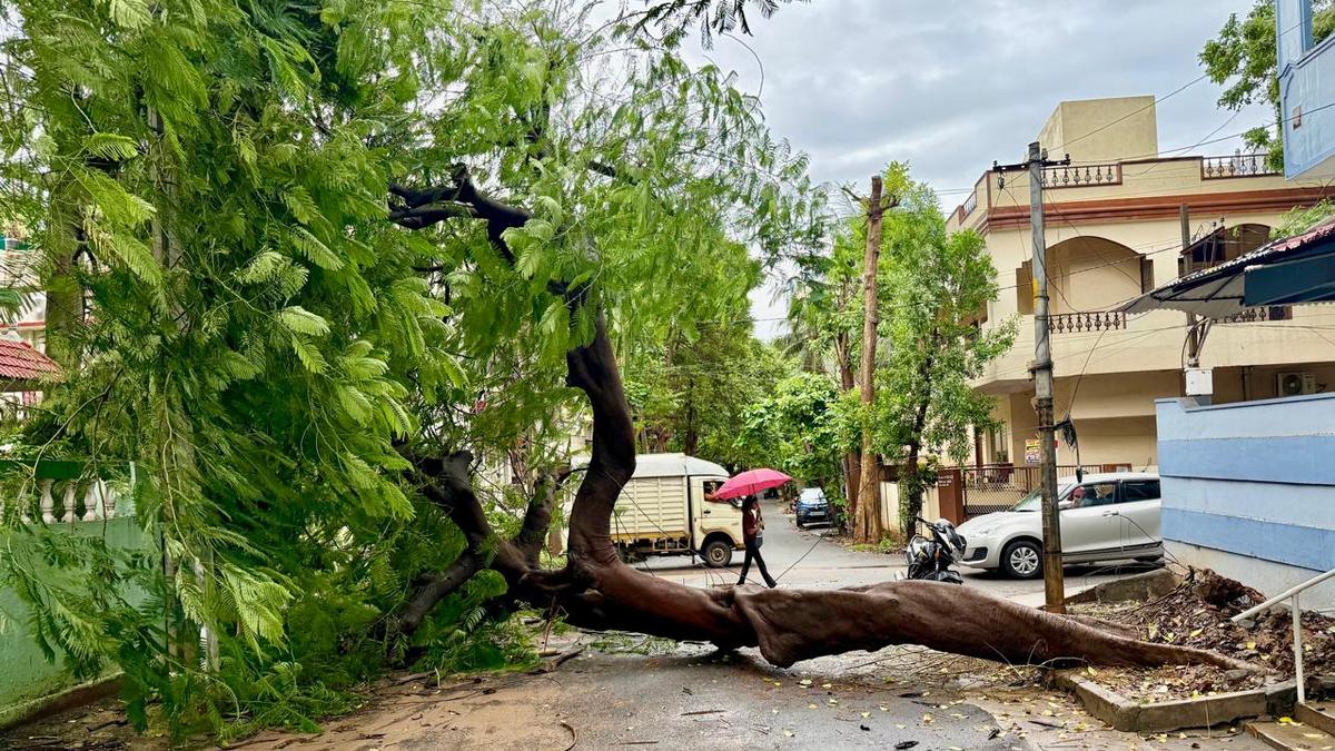


A pedestrian passes a tree that fell across a street at MVP Colony in Visakhapatnam late on Tuesday night after hours of continuous rain under the deep depression over the Bay of Bengal.
| Photo Credit: K.R. Deepak
A deep depression over the Bay of Bengal off the north Andhra coast will come ashore on Wednesday (September 23, 2026) night, somewhere between Visakhapatnam and Gopalpur in Odisha, most likely near Kalingapatnam, the India Meteorological Department (IMD) said. Officials at the Cyclone Warning Centre in Visakhapatnam said it had not grown into one and was likely to cross the coast at its present strength.
At 5.30 a.m. on Wednesday, the system was about 70 km off Kalingapatnam, 150 km from Visakhapatnam and 150 km from Gopalpur in Odisha, moving west at about 12 kmph. The IMD expects it to turn slightly north and cross the coast between Visakhapatnam and Gopalpur.

A meteorological tracking map illustrating the projected trajectory and intensity of the deep depression over the Bay of Bengal as it advances toward landfall along the north Andhra Pradesh and south Odisha coasts.
| Photo Credit:
IMD
Is it a cyclone? No. On the IMD’s scale, a deep depression means winds of 52 to 61 kmph around the centre; a cyclone begins at 62 kmph and gets a name. Officials at the Cyclone Warning Centre in Visakhapatnam said this system had not grown into one and would cross the coast at its present strength. Once over land it should weaken to a depression by Thursday evening, stay that way through Friday and fade into an ordinary low-pressure area by Saturday morning. The coast will feel it before then: gusts of 55 to 75 kmph are likely on Wednesday and Thursday, and fishermen have been told to stay off the sea till Friday (September 25, 2026).
In the 24 hours to 8.30 a.m. on Wednesday, the heaviest fall anywhere under the system was in Odisha’s Koraput district, where Simliguda got 230 mm and Jeypore 162 mm. In Andhra Pradesh, Palasa in Srikakulam district got 141 mm, the most in the State, and Sompeta, Kalingapatnam and Tekkali in the same district each got more than 110 mm. Araku Valley in Alluri Sitharama Raju district recorded 100 mm and Visakhapatnam city 90 mm.
| IMD Station (district, State) | Rainfall (mm) |
| Simliguda (Koraput, Odisha) | 230.2 |
| Jeypore (Koraput, Odisha) | 161.6 |
| Palasa (Srikakulam, A.P.) | 141.4 |
| Borigumma (Koraput, Odisha) | 138.2 |
| Fentulikhunti (Nabarangpur, Odisha) | 138.0 |
| Sompeta (Srikakulam, A.P.) | 134.6 |
| Nandahandi (Nabarangpur, Odisha) | 128.0 |
| Balasore (Balasore, Odisha) | 126.4 |
Source: IMD
Of the State’s 2,218 automatic rain gauges, 173 recorded heavy rain (64.5 mm or more) in those 24 hours, all of them in the north. Srikakulam’s 70 stations averaged 76 mm, and 42 of them had heavy rain. Visakhapatnam’s 104 stations averaged 69 mm.
| District | Rainfall (mm) |
| Srikakulam | 75.7 |
| Visakhapatnam | 68.9 |
| Alluri Sitharama Raju | 60.8 |
| Vizianagaram | 60.4 |
| East Godavari | 43.8 |
| Anakapalli | 43.1 |
| Parvathipuram Manyam | 42.9 |
| Kurnool | 15.2 |
Source: DES-AP
Between 8.30 a.m. and noon on Wednesday, the highest reading anywhere in the State was 34 mm, at Vajrapukotturu in Srikakulam district, and the showers had moved down the coast to Krishna, Eluru and West Godavari districts, where several places got 20 to 27 mm.
The overnight rain left its mark; tanks and streams overflowed around Palasa and elsewhere in Srikakulam district, and low-lying roads went waterlogged. In Visakhapatnam, trees came down at MVP Colony late on Tuesday night and near Dr. L. Bullayya College on Wednesday morning, and Greater Visakhapatnam Municipal Corporation (GVMC) crews cut them up to reopen the roads. A boundary wall at the site of Google’s data centre at Mudasarlova had also collapsed. No one was hurt in any of these.
A red alert is in force till Thursday morning for Srikakulam, Parvathipuram Manyam, Vizianagaram, Alluri Sitharama Raju and Anakapalli districts, where heavy to very heavy rain is likely in places along with winds of 50 to 60 kmph, and an orange alert for Visakhapatnam. On Thursday, the alert drops to orange across the region, and to yellow from Friday. District officials along the northern coast have been told to stay on alert until the system crosses.
Deputy CM’s orders to rural staff
Deputy Chief Minister K. Pawan Kalyan, who also holds the Panchayat Raj and Rural Development portfolio, directed his department’s officials to remain fully vigilant, in a statement from his office on Wednesday that referred to “cyclone warnings” in the State. He said north Andhra would be hit hardest and asked officials to warn people accordingly.
He told them to plan for damaged culverts, breached rural roads and fallen trees, and to repair damaged roads on a war footing. Where floods were severe, officials were to help run relief camps, move people to safety, and see that the camps had food, clean drinking water and medicines. He also asked for fodder and water for livestock, and for the Revenue, Police, Electricity, Medical and Health, and Animal Husbandry departments to work together so that power supply was not disrupted.
Published – September 23, 2026 02:41 pm IST