


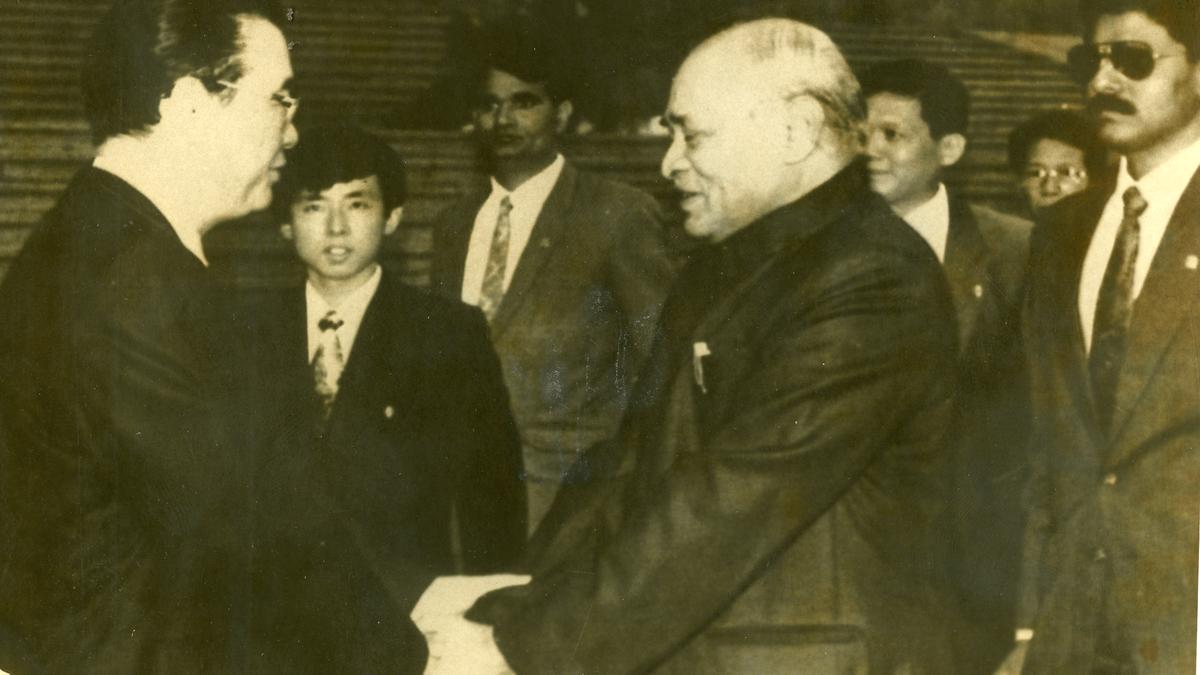
India has a complicated history with regards to its border with China. Rajiv Gandhi’s December 1988 visit to Beijing was the beginning of a short pause in India-China border relations due to political turmoil in India. With the defeat of Rajiv Gandhi in the 1989 elections and the short lives of the V.P. Singh and Chandrashekhar governments that lasted till early 1991, the government had its hands full. Following the 1991 elections and the assassination of Rajiv Gandhi, a minority government headed by P.V. Narasimha Rao took office but with its first priority being to deal with the deep economic crisis confronting India.
Therefore, it was only in 1992 that the government was able to re-focus on China. By this time, both governments saw a congruence of sorts in their economic opening to the world and the need for peace and tranquillity on their border.
Six rounds of talks by the Joint Working Group (JWG) on the border issue were held between December 1988 and June 1993. The two sides got the military into the dialogue process, and at the fourth meeting (February 1992) there was an agreement for military commanders to meet at Bum La in the eastern sector and at the Chushul/Moldo meeting point in the western sector. Moreover, border trade resumed in July 1992 after a gap of more than 30 years; consulates reopened in Mumbai and Shanghai in December 1992; and, in June 1993, the two sides agreed to open an additional border trading post. During Sharad Pawar’s July 1992 visit to Beijing, the first ever by an Indian defence Minister, the two defence establishments agreed to exchange academic, military, scientific, and technological developments.
During the sixth meeting of the JWG from June 25 to 30 in 1993, the two sides more or less worked out an agreement, often called the Border Peace and Tranquillity Agreement (BPTA), that was later signed when Prime Minister Narasimha Rao visited Beijing in September 1993. The BPTA was a logical consequence of the movement in Sino-Indian relations since 1979.
Towards peace and tranquillity
With the swap deal (wherein China proposed the idea of India conceding the Aksai Chin and parts of Ladakh to China in return for China acknowledging India’s claim over Tawang and other parts of Arunachal Pradesh) going off the table, the need for the BPTA was manifest. But it was clear that there could be no peace till the two sides had at least a commonly recognised border. For this reason, India accepted the notion that it was currently the Line of Actual Control (LAC).
The nine-article agreement’s very first article laid out its core — that the Sino-Indian boundary question shall be resolved through peaceful and friendly consultations. “Neither side shall use or threaten to use force against the other by any means.”
The article also spelt out the choreography that would be followed on the LAC — neither would overstep the LAC, and in case they did, they would withdraw “upon being cautioned by the other side.”
Further, the two sides would, when necessary, “jointly check and determine the segments of the line of actual control where they have different views as to its alignment.” In fact, this is the first Sino-Indian document that referred to the LAC as such.
The other clauses, too are significant in the context of transforming the Sino-Indian relationship. Article II noted that both sides would maintain minimal forces in the areas along the LAC.
A very significant sub-clause noted that “the two sides would reduce their forces on the principle of mutual and equal security to ceilings to be mutually agreed.” The clause spelt out that this reduction would take into account the geography of the region. This is important because while Chinese forces have easy access to their forward posts by roads built on the Tibetan plateau, it often took Indian forces a great deal of time, sometimes days, to reach their posts.
These and various other clauses clearly indicated that the two sides were in agreement on the need to freeze the situation along the LAC. And the sum total of the agreement was to set aside the boundary issue and build good relations on other fronts.
The 1996 agreement
The BPTA agreement must be seen in conjunction with the agreement of 1996 during the visit of Jiang Zemin to New Delhi that extended and expanded on the 1993 agreement, especially in relation to military confidence-building measures (CBMs).
The agreement reiterated the commitment of the two sides not to use force against each other and to seek a “fair, reasonable and mutually acceptable settlement of the boundary question.” Pending this, the two sides committed themselves to respect the LAC and not overstep it.
The two sides agreed to “reduce or limit” their military forces and paramilitary, as well as specific armaments such as combat tanks, combat vehicles, howitzers and artillery and mortars of 120mm or more, surface-to-surface and surface-to-air missiles, and to work out ceilings on military forces in specific areas.
Article IV noted that the two sides would avoid holding large scale military exercises in proximity to the LAC and if they were held, the direction of the exercise would be away from the other side. This was the article that was violated by China in eastern Ladakh in 2020.
Article X was another important article and the inability of the two sides to implement it undermined their overall efforts.
This was the admission that the full implementation of the provisions of the agreement would depend on the two sides arriving “at a common understanding of the alignment of the Line of actual control “.
They needed to speed up the process of clarification and confirmation, and agreed to exchange maps indicating their respective perceptions of the entire alignment of the LAC.
No common definition
At the eight JWG meeting in March 2000, the two sides exchanged maps of the relatively undisputed Central sector but the process was not able to extend to the eastern and western sectors. According to reports, in June 2002, the countries exchanged maps of the western sector, but within 20 minutes the maps were returned by both sides because, according to Ranjit Kalha, the maps represented the maximalist positions of both the sides, and neither was comfortable with accepting them. At the time, there were differences of alignment at Samar Langpa, Trig Heights, Depsang, Kong Ka La, Pangong Tso, Spanggur Gap, Mount Sajun, Dumchele, Demchok, and Chumar in the western sector. By 2005 both sides abandoned efforts on this front. Not surprisingly, many of these areas have figured in the Sino-Indian border face-offs subsequently, as well as in 2020. With the two sides unwilling or unable to clearly define the LAC, it was but inevitable that there would be faceoffs between the two sides. What they could have done was to work out ways and means to prevent these face-offs from becoming clashes. But as time went on, this became more difficult.
Manoj Joshi is a Distinguished Fellow at Observer Research Foundation, New Delhi. This is the second of a three part series on India-China border relations.
Published – September 08, 2025 08:30 am IST