


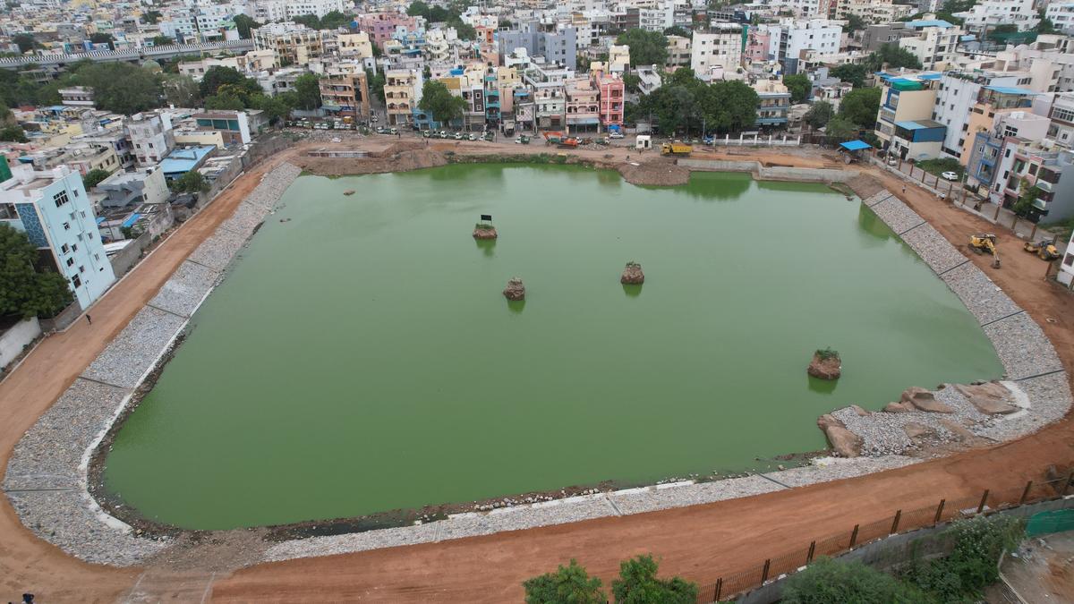

Bathukamma Kunta at Amberpet, Hyderabad, in the process of revival.
| Photo Credit: ARRANGEMENT
Bathukamma Kunta, the area in Amberpet which has had a water body merely in the name for past two decades, now shows an actual ‘Kunta’, which in Telugu means pond.
The Hyderabad Disaster Response & Asset Protection Agency (HYDRAA), on Tuesday, shared pictures of the water body, with ongoing embankment works taken up by the agency.
Sharing the aerial view of the pond, HYDRAA chief A.V.Ranganath said the lake rejuvenation works are going in in full swing, and are expected to be completed by this September.
Bathukamma Kunta is one of the six lakes taken up by HYDRAA for rejuvenation, the others being Bam Rukn-ud-Daula, Thammidikunta, Sunnam Cheruvu, and two Nalla Cheruvus, one in Uppal and another in Kukatpally.
Works at Bathukamma Kunta started around February, when the excavators machinery deployed by HYDRAA yielded copious amounts of ground water. HYDRAA issued a statement that this was proof of a lake existing at the location, which was disputed by a plaintiff who approached the court. Towards the last week of April, the city civil court ruled in favour of HYDRAA, after which the works gathered pace.
Constructed on all four sides and devoid of vegetation, the water body, despite all the efforts by the agency, looks more like an artificial pool of the sort created in a resort as of now. Closed in by a walking track and defined in its shape, the pond is filled with green, slimy water.
When approached, Mr.Ranganath clarified that it was ground water mixed with stormwater from surrounding localities, stagnated for two months. Arrival of stormwater is facilitated by the inlet drain constructed after diversion of sewage.
Mr. Ranganath added that the outlet channel up to Musi river is still a work in progress. It will be a challenging task, he said, as the drain has to find its way through heavily constructed localities. Once the task is completed, the pond will have fresh water.
According to the maps displayed on the website of the Hyderabad Metropolitan Development Authority (HMDA), Bathukamma Kunta was first surveyed in 2013, when its full tank level (FTL) perimeter was determined as about 1.4 kilometres. No water spread was mentioned, nor the FTL in acres, but the area surveyed by the consultant was over 14 acres.
Historical satellite images since 2010 show that the lake had never had water, with all inlets and outlets closed on all sides. It remained dry even during the 2020 floods when several lakes overflowed in the city. The survey of India maps, however, vouch for the existence of a water body there.
The FTL area got heavily encroached even after the survey, with multiple structures cropping up within, as visible from the satellite images. The Lake Protection Committee, which was constituted under HMDA in 2010, did precious little on this front, with final notification of the lake still pending. The water body developed by HYDRAA occupies only a portion of the original lake.
Published – July 09, 2025 01:16 am IST