HYDERABAD
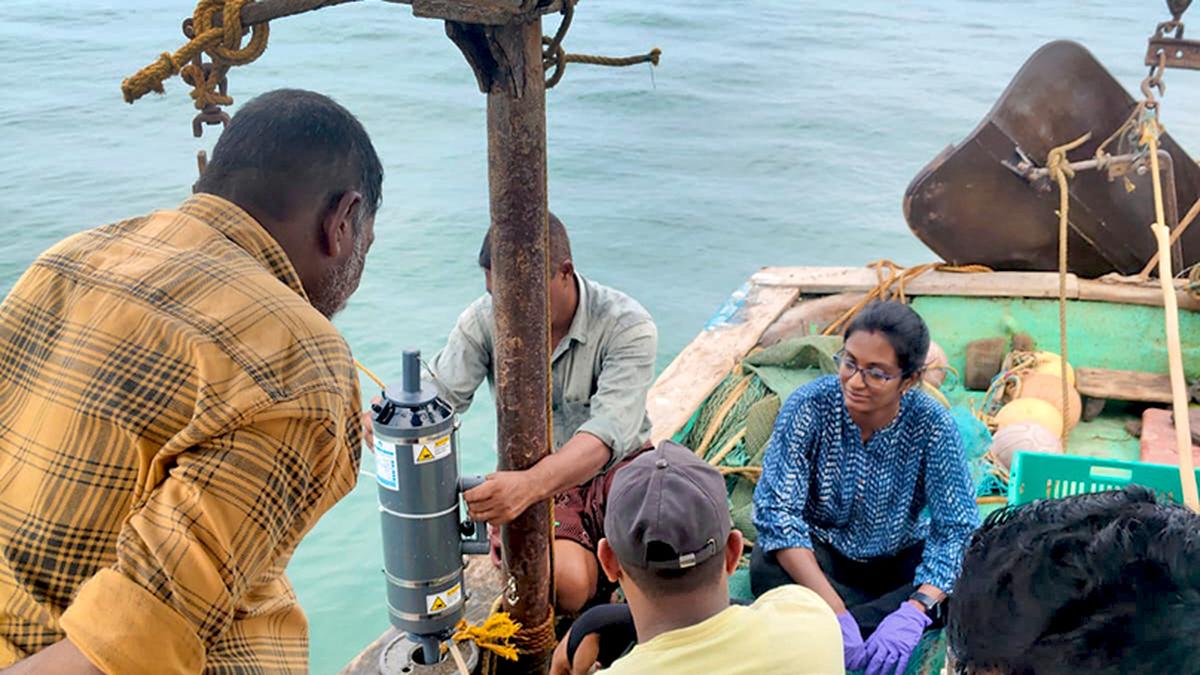
Fishermen will soon join hands with scientists at the Indian National Centre for Ocean Information Services (INCOIS), an autonomous organisation under the Ministry of Earth Sciences headquartered in Hyderabad. As part of a citizen-science initiative, their nets will be fitted with small sensors to gather real-time data on ocean conditions. INCOIS is testing low-cost sensor models with various original equipment manufacturers (OEMs) to make this possible.
“Once we establish a micro-observation system within the fishing nets, it will provide a more accurate picture of the ocean. At present, we are connected with nearly nine lakh fishermen across coastal regions of the country, who receive our daily Potential Fishing Zone (PFZ) advisories in their local language. Our next step is to involve them directly in our research activities,” said INCOIS director T.M. Balakrishnan Nair.
INCOIS has operationalised a mobile app for the fishing community, through which fishermen can capture images of their catch at sea and transmit them directly to the INCOIS server. This initiative is designed to enhance marine fishery advisory services by integrating catch observations with satellite and model data to identify fishing grounds and assess habitat conditions.
“We are about to begin a pilot project. Currently, our fishing advisories rely on satellite data such as sea surface temperature and chlorophyll levels to predict where fish are most likely to be found. By adding real-time information from fishermen at sea, we can make these advisories more accurate,” Mr.Nair said.
Scientists at INCOIS are now preparing to sign an agreement with the Ministry of Fisheries and the Indian Space Research Organisation to establish a two-way communication system extending up to 1,500 km into the sea. Earlier, the institute launched an app called ‘Samudra’ (Smart Access to Marine Users for Ocean Data Resources and Advisories), which provides comprehensive ocean-related services for seafarers and fishing community.
The app delivers real-time updates and alerts on oceanic hazards such as tsunamis, storm surges, high waves and swell surges, along with PFZ advisories to guide fishermen to probable fish aggregation areas.
“However, fishermen cannot be contacted beyond mobile coverage area. With support from the Fisheries Department to fund the installation of Gemini/NaVIC systems, fishing boats will now be equipped with these devices, enabling communication up to 1,500 km from the coast,” he explained.
In 2019, INCOIS launched the Gagan Enabled Mariner’s Instrument for Navigation and Information (GEMINI) in collaboration with the Airports Authority of India. The device uses GAGAN (GPS Aided Geo Augmented Navigation) satellite system to provide fishermen with ocean state forecasts on winds, waves, currents and sea surface temperature. NavIC is ISRO’s regional navigation satellite system, known as Navigation with Indian Constellation.
While mobile connectivity extends only up to about 12 km from the coast, the Gemini-NaVIC devices operate via satellite and are relatively expensive. With the Fisheries Department agreeing to fund these devices for the benefit of fishermen, the communication system will become significantly more robust,” Mr. Nair said.
INCOIS will set up and operate the main satellite reception centre on its Hyderabad campus, where preparations are under way. The agreement between the departments concerned is expected to be signed soon.
In view of the growing demand for ocean-related satellite data, INCOIS has approached the Ministry of Science and Technology to request a dedicated satellite for ocean observations, aimed at delivering more accurate and impact-based forecasts. Mr. Nair noted that the satellite data currently available from both indigenous and international sources often have significant gaps, sometimes with intervals of up to 22 days.
“Ideally, we would like to access satellite data at three-hour intervals. We are hopeful that the recently approved new-generation constellation of micro-satellites by the Centre will provide improved data for more advanced forecasts. We are also open to collaborations with other agencies,” he said.
Earlier this year, a long-range ‘sea glider’ was launched near India’s research station Bharati in Antarctica, in collaboration with the National Centre for Polar and Ocean Research (NCPOR), to study sea temperature, salinity and geochemical processes in the icy waters. Having already covered 5,000 km, the glider is now on its way toward the Gujarat coast.
“At present, the sea glider is near Kenya and is being monitored round the clock. It is pre-programmed, and once retrieved, it will provide valuable insights into ocean conditions. We are also planning to deploy a few more gliders,” said the director.
INCOIS has already deployed six gliders in the Indian Ocean to monitor ocean parameters. These gliders can travel up to 1,000 km from the coastline at a speed of 15 km per day, dive to depths of 1,000–2,000 metres, and are remotely operated from the command centre, manoeuvring both vertically and horizontally at about eight cm/s.
“Equipped with advanced sensors, the gliders track ocean parameters like chlorophyll, oxygen, salinity and temperature. They send basic updates in real time several times a day, while the full set of detailed data is collected when their batteries are replaced after about nine months,” he concluded.
Published – August 30, 2025 12:15 am IST


